|
New Products:
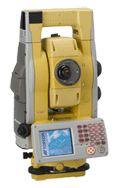
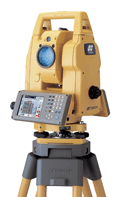
Topcon recently introduced two products
at the cutting edge of the world of robotics,
the GPT-9000 and GTS-900.
This is Topcon's 6th generation of robotics
and the experience really shows. There
is absolutely no question this new innovative
system represents the very best technology
in the market today. The systems are
smaller, faster and lighter than ever before
while maintaining accuracy and increasing
range capability.
This new series is revolutionary in several
areas such as measuring range, turning
speed, wireless capability and ease of operation. The GPT-9000 has the
longest reflectorless range in the industry, 2000m (6,560 ft.). The
turning speed is an extremely quick at 15 degrees per second. Add to all
that, the entire system is wireless. That is right NO cables of any kind. The
level of automation has made these robots the simplest ever to set up and run.
Experience the latest in Topcon's Robotic
innovations.
Contact us now for complete details
and specifications.
GPT-9000
Total Robotic Station |
 |
Click
here to
download product literature |
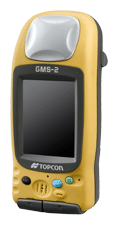
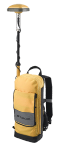
The GMS-2 is
a small hand held dual constellation satellite
tracking receiver that is packed with features
and performance. The GMS-2 was specifically
designed with the GIS market in mind. It
is small, very light weight, extremely
portable and quite user friendly
GMS-2
Dual Constellation Satellite Tracking
Receiver |
 |
Click
here to
download product literature |
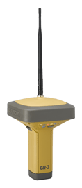
Topcon Positioning Systems, Inc. officially
announced the launch of the GR-3
GNSS receiver. This is the
first of what will be a complete lineup
of new systems that will utilize the new
advanced Paradigm-G3 chip (GPS, Glonass,
and Galileo). The GR-3 receiver represents
the next generation of advanced system
design and tracking technology from Topcon.
GRS-3
GNSS Receiver |
 |
More
info coming soon! |
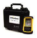
OfficeSync enables field
crews to send field data directly to the
office without leaving the job site. And
it works both ways. The office can
send stakeout jobs, or any other files,
directly to their field crews with the
click of a button.
This is a valuable resource all the way
around! Get your crews into the field
quicker. Save valuable time in the
office by eliminating loading and downloading
files for the field crews. Eliminate
at least a portion of the crews driving
time to and from the office. Save
time and fuel!
Need critical field data as quick as possible? OfficeSync
can send that critical data to the office
within seconds after the last point has
been collected. The crew can even
send the data from the job the just left
as they are driving to the next job. How
impressive is that!
The system is extremely simply and straight
forward. You and your crew can be
trained in virtually minutes. Work
wireless use OfficeSync!
OfficeSync
Field Data Collection & Management
Suite |
 |
Click
here to
download product literature |
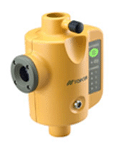
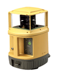
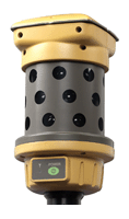
Millimeter GPS offers the most accurate
elevation control ever when used in combination
with GPS+. The system is made up of at least
two components, PZL-1 laser transmitter
and a PZS-1 rover sensor. For machine control
applications you simply add a PZS-MC machine
control sensor to complete the system.
PZS-1
Positioning Zone
Sensor |
 |
Click
here to
download product literature |
PZL-1
Positioning Zone
Laser
Transmitter |
 |
Click
here to
download product literature |
PZS-MC
Machine Control
Sensor |
 |
Click
here to
download product literature |
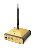
HiPer XT- RTK Integrated GPS+ Receiver
In addition to all of the standard HiPer
features such as integrated antenna, battery
and radio the HiPer XT has a unique UHF
radio that allows for two methods of operation.
This is the only HiPer that has a UHF transmit
and receive radio with “clear channel”
capability called TPS mode. Or, you can
operate in the PDL mode allowing for backward
compatibility. In addition, this feature
packed receiver also has built in GSM capability!
HiPer XT- RTK
Integrated GPS+
Receiver |
 |
Click
here to
download product literature |
GMS-110- GIS Mapping Receiver
The GMS-110 is a multi-purpose GIS/Mapping
System that incorporates all of the primary
position correction services- Beacon, WAAS,
EGNOS, and OmniSTAR. The GMS-110 also offers
integrated Bluetooth wireless technology.
The GMS-110 offers sub-meter accuracy with
real-time differential correction. You can
select your choice of controller software
either ESRI ArcPad or Topcon’s own
TopSURV-GIS in combination with our FC-100
hardware.
GMS-110
Mapping Receiver |
 |
Click
here to
download product literature |
GPT-7000i
The GPT-7000i is another Topcon product
that deserves the “World’s First”
title. This is the first imaging total station
to ever hit the market.
A combination of a built in digital camera
and some very powerful software allows the
user to display the image of what you would
normally see by looking through the telescope
on the display of the instrument. There
are uses for this type of technology in
the market place today.
GPT-7000i
Imaging Total Station |
 |
Click
here to
download product literature |
Please click
here to contact us |